 |
|||||||||||||||||||||||||||||||||||||||||||||
Volume 3, Number 7, April, 2012 |
|||||||||||||||||||||||||||||||||||||||||||||
|
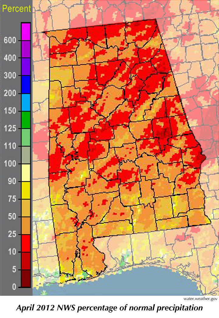
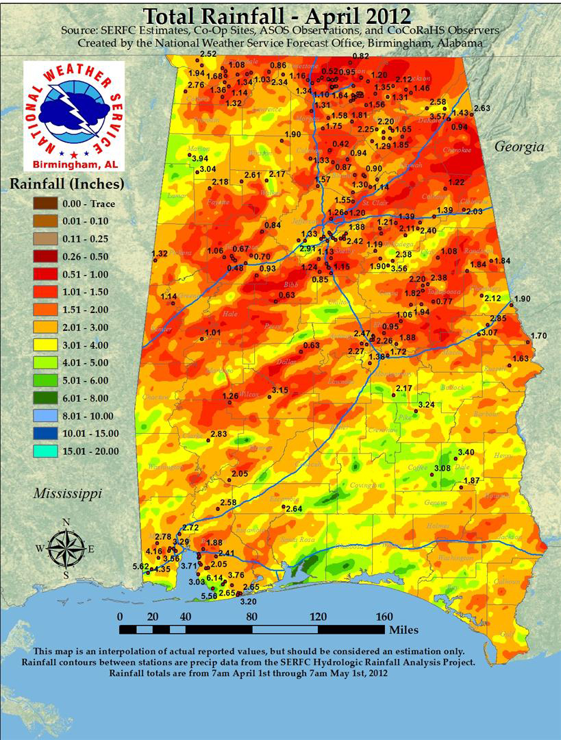
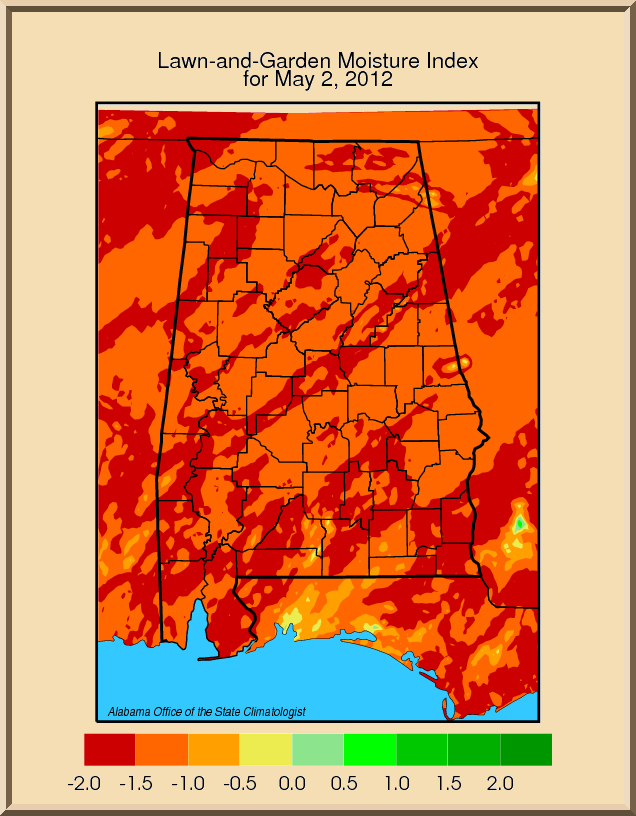
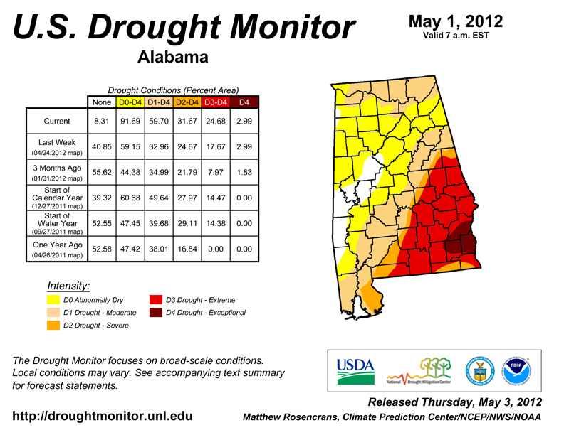
You have probably heard by now that for the first time since 2004 Alabama got through April without a single tornado — not even a tornado warning. Having an April without a tornado is unusual, but it turns out that it isn't exactly "rare." In the Doppler weather radar era, which started about 1992, the state has seen four tornado-free Aprils: 1993, 2001, 2004 and, now, 2012. In the 50 years before Doppler radars were installed around the country, Alabama had eleven Aprils without tornados, so pretty close to one April out of five before and after. Of course, a number of tornadoes that would be counted now weren't in years past because we had neither the radar hardware nor the network of trained storm spotters that we have now. A month without tornadoes was the good news from April. Unfortunately, the weather systems that kept Alabama free from nature's most violent storms also pushed away most of the rain. About half of the state saw less than 50 percent of its normal rainfall in April. The portion of Alabama designated as being in a drought more than doubled in April, from 42 percent on March 27 to almost 91 percent on May 1. Nearly all streams in the state are well below their average flow for this time of year, some in the one-in-100 year lowest level. The U.S. Army Corps of Engineers has started drought operations on the Chattahoochee and Appalachicola rivers, trying to maintain at least a minimum flow. It would be nice to know what May and the summer will bring. With the La Niña Pacific Ocean cooling event all but gone, however, any prediction for weather in May and the summer months should be taken with great caution. That is especially true since May can have all sorts of weather, everything except winter storms and hurricanes. In May we have seen floods and droughts, heat waves and cool, hail, high winds and tornadoes. You might recall that last month we talked about March 2012 being close to the warmest March on record. It was close, but not a record. March 2012 finished 0.1° Fahrenheit cooler than March 1907, placing it second. That extra warmth led to a quick greening of plants and trees, with their associated thirst. Let's hope March flowers don't give way to the May browns and yellows of ongoing drought. |
|
|||||||||||||||||||||||||||||||||||||||||||
| - John Christy | |||||||||||||||||||||||||||||||||||||||||||||
|
|||||||||||||||||||||||||||||||||||||||||||||
 |
|||||||||||||||||||||||||||||||||||||||||||||
| Copyright (c) 2010-2011 Alabama Office of the State Climatologist. All rights reserved. questions about this web page? Contact webmaster. |
|||||||||||||||||||||||||||||||||||||||||||||