 |
||||||||||||||||||||||||||||||||||||||||||||
Volume 3, Number 6, March, 2012 |
||||||||||||||||||||||||||||||||||||||||||||
|
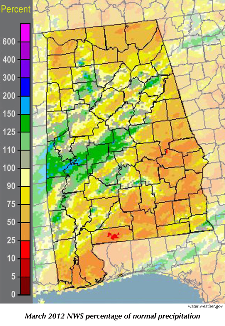
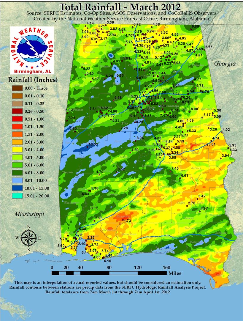
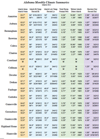
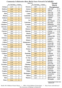
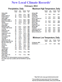
It isn't "officially" a record — yet — but this March will certainly go into the books as one of the hottest (if not the hottest) March in the state's 117-year climate history. Huntsville and Muscle Shoals officially had their hottest March on record: Huntsville's 63.4° average temperature for the month was 9.9° warmer than the normal, while Muscle Shoals was 10.1° warmer than normal with a March mean temperature of 63.3°. Mobile had its second warmest March, with a 68.3° mean that was 8.1° warmer than normal. Of the cities we report in the attached climate summary, the "statewide" average temperature of 64.3° was 9.1° warmer than normal for March. All ten of the state's largest cities were eight or more degrees warmer than normal for the month. Compared to seasonal norms, Decatur was the warmest city in the state in March. City March Anomaly The official statewide mean temperature takes some time to gather and calculate, since it comes from several sources. We will keep an eye on the National Climate Data Center website to see where March 2012 ranks. The warmest March on record was in 1907, when the statewide average temperature was 9.05° warmer than the statewide 55.45° March norm. The "norm" that we use for our selected cities in this report is a couple of tenths cooler than the official norm, so we'll have to wait for the official report to know where March 2012 stands. On the other hand, we know that Alabama's winter of 2011-12 was the 12th warmest in the past 117 years, with a statewide average temperature (50.7° Fahrenheit) that was almost 5° F warmer than the long-term average. It was also the warmest winter (Dec-Feb) since 1999. Of course, winter is the season with the greatest temperature variability. There is a spread of more than 15° F between the state's warmest winter on record, 55.5° in 1932, to the 40.0° during the winter of 1977-78. According to data from the National Climatic Data Center, Alabama's 117-year average winter temperature is 46.87°. There has been a slight cooling trend — -0.07° F per decade — during that time. Lest anyone connect Alabama's warm 2011-12 winter with a warming trend: The winter of 2010-11 was the state's 14th coldest on record, while the winter before that was the fourth coldest. Also linked to this month's Alabama Climate Report, you may note the addition on a link to a site that discusses research scientists here have been doing on the April 27, 2011, tornadoes and the storms that spawned them. We are coming up on the one-year anniversary of that day. The scientists and students who are studying what happened that day have learned quite a bit about what made those storms unique, as well as how we might better protect ourselves from future storms. Let's all hope that this April is much calmer and less traumatic than the last. |
|
||||||||||||||||||||||||||||||||||||||||||
| - John Christy | ||||||||||||||||||||||||||||||||||||||||||||
|
||||||||||||||||||||||||||||||||||||||||||||
 |
||||||||||||||||||||||||||||||||||||||||||||
| Copyright (c) 2010-2011 Alabama Office of the State Climatologist. All rights reserved. questions about this web page? Contact webmaster. |
||||||||||||||||||||||||||||||||||||||||||||