 |
|||||||||||||||||||||||||||||||||||
Volume1, Number 11, August, 2011 |
|||||||||||||||||||||||||||||||||||
for more info go to:
|
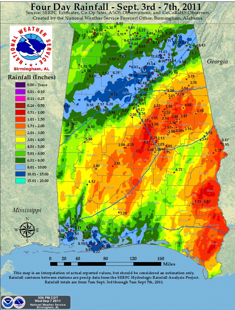
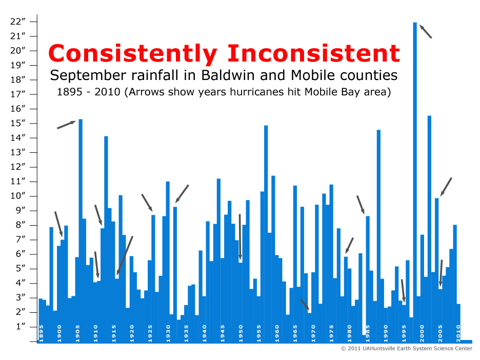
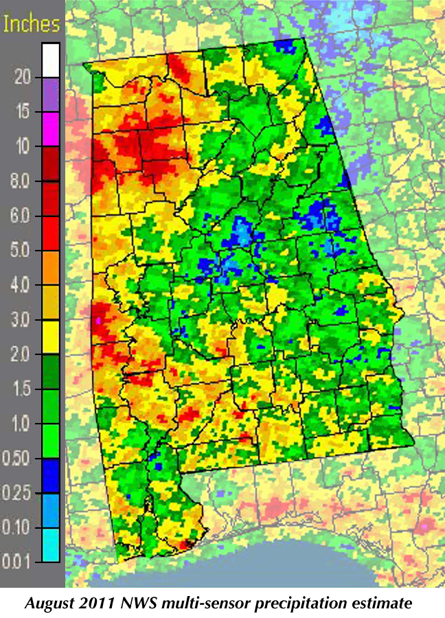
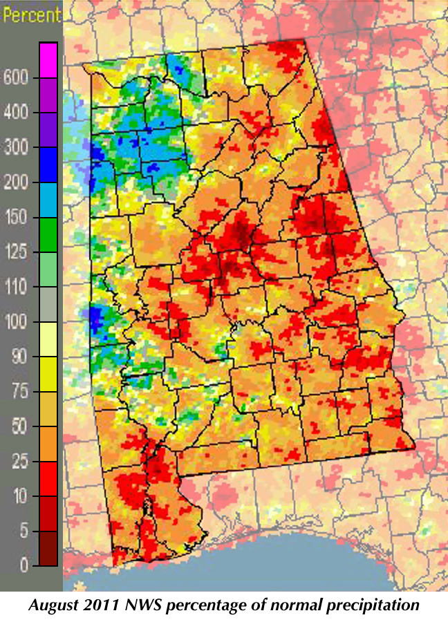
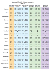
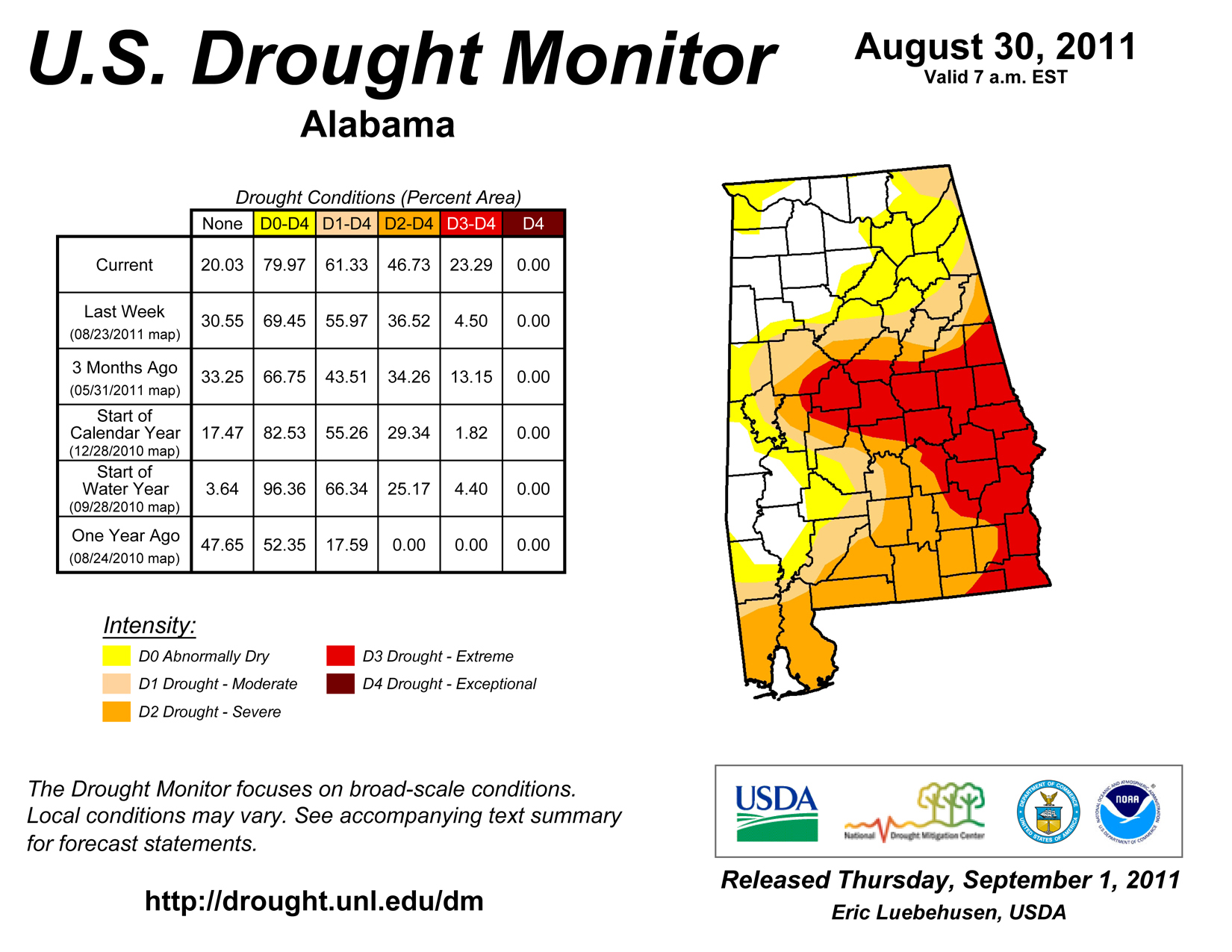
While September is off to a wet and cool start, August was a hot, dry month for most of Alabama (although hot and dry isn't much of a surprise for August). Drought did spread across much of the state as little rain fell in the last three weeks on the month. We saw one month-long record broken last month: With only 0.40 inches of rain for the month, Anniston had its driest August on record. That broke the 0.5” record set in 1983. Crops across the state have been damaged either by the early drought in the northern half of the state or the more recent drought in the southern and eastern portions of Alabama. September is a month of transition between the end of summer and the beginning of autumn. It can be cool and extremely wet, especially if a tropical system such as Tropical Storm Lee washes across the state. Lee brought between seven and eleven inches of rain to some parts of Alabama, causing flooding and road closures. Birmingham schools closed today due to dangerous conditions on roads and damage to some schools. More than 180,000 people have been without power due to storm damage. Rain fell in bands, leaving some areas relatively damp but others saturated. The storm dropped 11.6 inches on Mobile, more than ten inches on Grand Bay and seven to more than nine inches of rain on Orange Beach, Foley and Fairhope. Guntersville got 10.9 inches of rain, Muscle Shoals just over six inches and Huntsville almost five, but less than two fell on Decatur. Gadsden had just over seven inches, while record-dry Anniston got 1.73 inches. Heavy rain might be welcome in an area gripped by serious drought. But with tropical systems it seems we have to choose between too little and way too much. And tropical systems are one of our climate's major driving forces. If you look at the attached graph of September rainfall totals for Baldwin and Mobile counties, the most obvious feature is the remarkable variability. At the peak of the hurricane season, weather along the coast is consistently inconsistent. Tropical rainfall and its related flooding damage more than property: Freshwater flooding is the number one cause of hurricane-related death, accounting for more deaths than wind and storm surge combined. After watching the flooding that hit much of the east coast after Hurricane Irene, we were well advised to take appropriate precautions. It doesn't take a powerful hurricane to cause tremendous flooding. At the same time, September can also be hot and dry. In 1925, for instance, after the state's driest summer on record, many stations saw their highest temperatures ever that September. That included Centreville, which set the state's all-time high temperature record at 112° F on Sept. 5, 1925. On that day every reporting station in Alabama had a high temperature above 100°, a feat that has never been repeated. All across the state daily high temperatures set records, including many that stood through last September. From Sept. 3-9, 1925, Huntsville saw high temperatures of at least 103°, hit 107° three times and peaked at 108° on Sept. 7. The average high temperature in Huntsville for September 1925 was 97.5°, compared to the normal September average high of 83°. On another historic note, this September marks the 85th anniversary of a major hurricane that hit South Alabama after devastating much of South Florida. The storm was blamed for at least 373 deaths, but left one positive legacy: In response to the widespread destruction of buildings, Miami enacted and enforced the nation's first building code. That has been duplicated in most of the towns and cities in the U.S., leading to safer and more storm resistant housing and public buildings for many of us. |
|
|||||||||||||||||||||||||||||||||
| - John Christy | |||||||||||||||||||||||||||||||||||
|
|||||||||||||||||||||||||||||||||||
 |
|||||||||||||||||||||||||||||||||||
| Copyright (c) 2010-2011 Alabama Office of the State Climatologist. All rights reserved. questions about this web page? Contact webmaster. |
|||||||||||||||||||||||||||||||||||