| |
|
|
Infrared
Infrared
Band Differencing:6.5-10.7 micron
Infrared
Band Differencing:13.3-10.7 micron
Infrared Band
10.7 micron
(click
image to enlarge)
 |
Channel 2 on the current GOES satellites (GOES-8 through 12) senses radiation
over a spectral range that is centered at about 3.9 microns which
contains both reflected solar energy and emitted terrestrial energy.
Since this wavelength contains reflected sloar energy, it cannot
be directly related to cloud-top temperature. Therefore, this channel
is not very useful if used alone. However, when used in combination
with the atmospheric window channel (10.7 micron) it can provide
a great deal of useful information. Click here for
more information on the 3.9 micron band.
The subtraction of the 10.7 micron brightness temeprature (TB)
from the 3.9 micron TB is useful for determining whether a cloud
top is composed of liquid water or ice. This product is commonly
known as the "fog
product" for its ability to detect low liquid water clouds (i.e.
fog and stratus), especially at night. A scientific description of this
product is provided in the following paragraph.
The imaginary index of refraction for both ice and water is higher
at 10.7 microns than at 3.9 microns. However, the difference
in this index is greater for ice clouds. Hence, ice clouds will
have larger 3.9-10.7 difference values than water clouds. Negative
values of this difference are indicitive of clear sky, due to
the fact that the earth's surface emits more at 10.7 microns
than 3.9 (the values for clear sky will vary depending on the
surface type). Values may be close to 0 for water clouds (blue).
The magnitude of the difference for ice clouds in this image
may also be dependent on the number of particles in the cloud
and the effective radius of the particle size distribution. In
this image, the areas with the largest differences (red or orange)
likely contain a higher concentration of ice particles, with
a smaller effective radius in the size distribution. Since the
3.9 micron channel contains a reflected solar energy component,
the values of this band subtraction will be different between
the day and night. Nevertheless, the greatest temperature difference
between these two bands will still represent the presence of high ice
clouds. An example of a nocturnal difference field over the Southeast
US is provided in the "Advanced Satellite Product Description" section.
This difference is not very useful for nocturnal analysis of convective
because of noise in the 3.9 micron channel at low TB's. Monitoring this
difference field over time can be quite useful in assessing convective
initiation. The transition from a cloud top dominated by liquid water
to an ice cloud often signals the onset of precipitation. Therefore,
by looking at temporal trends in this band difference, one can identify
vertically growing and potentially glaciating cumulus clouds.
As stated above, values of this band difference vary throughout the
day because radiation detected in the 3.9 micron channel contains a
reflected solar radiation component. Ice clouds with have a higher
difference value during the afternoon hours than at night. Although
this technique is very useful for characterizing cloud top microphysics,
we do not incorporate this technique into our CI assessment algorithm
due to the difficulty in accounting for variations in this technique
throughout the day. (back to top-->)
Infrared
Band Differencing:6.5-10.7 micron
(click
image to enlarge)
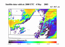 |
The 6.5-10.7 µm
differencing technique is useful for determining the cloud-top height
relative to the tropopause, or to very dry mid- and upper-tropospheric
air. Positive values of the water vapor-IR window temperature difference
have been shown to correspond with convective cloud tops that are at
or above the tropopause (i.e. overshooting tops), or growing into dry
upper tropospheric air where the water vapor band "saturates" near
the same altitude of the 10.7 µm temperature, in AVHRR and HIRS-2
(Ackerman 1996) and in METEOSAT-7 (Schmetz et al. 1997) data. In clear
sky situations, radiation at 6.5 µm is emitted by atmospheric
water vapor between approximately 20 and 50 kPa (Soden and Bretherton
1993). The radiation emitted at 6.5 and 6.7 µm by the surface
or low clouds is absorbed by atmospheric water vapor in the lower troposphere
and is not detected by satellites. On the other hand, absorption by
atmospheric gases at 10.7 µm is weak, and therefore, detected
radiation at 10.7 µm originates mainly from the surface. Because
the surface is normally warmer than the upper troposphere, the difference
between the 6.5 and 10.7 µm TB is usually negative. In regions
of intense convective updrafts, with cloud tops possibly extending
into the lower stratosphere, the 10.7 µm TB is colder than that
at 6.5 µm, resulting in a positive TB difference between these
bands. For the assessment of pre-CI signatures, convective clouds with
positive differences have likely already begun to precipitate, especially
in tropical atmospheres that support warm-top convection. Therefore,
clouds with moderately negative difference values (-35 to -10 K) represent
a useful CI interest field and imply the presence of low to mid-level
cloud tops (~85-50 kPa).
(back to top-->)
Infrared
Band Differencing:13.3-10.7 micron
(click
image to enlarge)
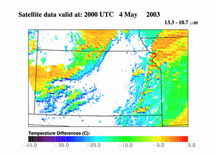 |
The 13.3-10.7
µm differencing technique is another measure used to characterize
and delineate cumulus clouds in a pre-CI state from mature precipitating
cumulus and cirrus in GOES-12 imagery. Limited documentation of this
band difference method is available (Hilger and Clark 2002), and
therefore this study may be the first organized use of this technique
for convective cloud studies (T. Schmit, NOAA, personal communications).
The subtraction of the 10.7-µm from the 13.3 um channel yields
similar results to the 6.5-10.7 µm technique for mature cumulus
clouds, but is much different for immature cumulus. As noted above,
the 6.5 µm channel detects emitted radiation mainly from the
upper troposphere. Therefore, large 6.5-10.7 µm differences
exist for immature cumulus clouds because the 10.7 µm TB is
much warmer than that sensed at 6.5 µm. In contrast, the 13.3 µm
channel detects radiation from the middle and lower troposphere.
As a result, the 13.3-10.7 µm difference values are much less
negative because the 13.3 µm TB is warmer than that of the
6.5 µm channel. For opaque cumulonimbus cloud tops, this band
difference yields values near zero because the 13.3 and 10.7 µm
bands detect equivalent TB's. The 13.3-µm channel is more sensitive
to thin cirrus (i.e. colder TB than the 10.7 µm channel), resulting
in slightly negative 13.3-10.7 µm differences. The 13.3-10.7 µm
difference would therefore appear to be a better indicator of low
cloud development (deepening) as compared to the 6.5/6.7-10.7 µm
technique.Cumulus clouds in a pre-CI state exhibit difference values
from -25 to -5 K for several convective storm events examined in
formulating CI interest field criteria. This range of difference
values will be used as a CI interest field within the CI nowcast
algorithm. Click here for
more information on the 13.3 micron band.
(back to top--> |