| |
|
|
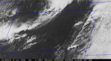
Visible
Product Descriptions
(click
image to enlarge)
 |
 |
The formation
of a satellite-based convective cloud mask is the first step in the
development of a CI nowcast. IR-based CI interest fields are computed
only where convective clouds are present, thereby excluding approximately
70-90% (on average) of a given satellite image from further processing.
This step greatly reduces the time required to produce a CI nowcast,
which allows for nowcasting in near real-time.
The convective cloud mask is based upon a multi-spectral region
growing (clustering) technique for classifying all scene types
in a GOES image. GOES pixels are clustered based upon statistical
similarity. The similarity threshold for each GOES channel is
user specified and is adjusted automatically based upon standard
deviation. The thresholds chosen for each satellite channel determine
how many clusters (i.e. scene types) are created. Currently,
we have chosen thresholds that produce 11 clusters. These clusters
include "uncertain"
(i.e. pixels that do not fall into any cluster), land, water, snow, stratus/fog,
semi-transparent cirrus, and 5 categories of convectively induced clouds.
A database of labeled clusters is created from a set of VIS and IR training
images over the area(s) of interest. The labeled cluster database forms
the basis of the pixel classification technique. Pixels are assigned
to a cluster based on the relationship between the pixel's multi-spectral
properties and those of the clusters identified in the database.
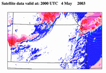
This classification system is produced at the 1 km GOES VIS resolution
and currently identifies 5 types of convectively-induced clouds: 1) small,
low-level cumulus (blue), 2) mid-level cumulus (cyan), 3) mature cumulus
clouds with depths extending through the entire troposphere (red), 4)
thick anvil ice clouds (magenta), and 5) thin anvil and cirrus clouds
(pink). For CI nowcasting purposes, analysis is primarily focused on
low- to mid-level cumulus pixels, as these clouds likely have not begun
to precipitate.
(back to top-->)
|