|

STUDY
AREA
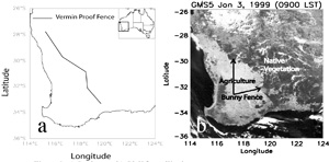
Currently a 750 km rabbit proof fence separates the croplands along the Southwest coast from native vegetation in the continental interior. Due to the high contrast in albedo between the croplands and native vegetation, the boundary separating these areas is a prominent feature in the satellite images for this region (Figure 1b). Environmental impacts of land use change in this region include alteration of subsurface water storage, regional climate and local hydrology. Extensive removal of native vegetation with deep roots has lead to rising of the water table with the end result of increased salinity in the surface soil and associated decrease in agricultural productivity. Rising soil salinity poses a serious threat to agricultural productivity in the future and has serious economic consequences. Several studies show connections between land use change and regional climate of this region (Lyons et al., 1993, Lyons et al., 2001, Ray et al. 2003). A 20% decrease in rainfall has been reported in this area following substantial clearing of native vegetation (Lyons et al., 1993), but is not completely clear if the decrease in rainfall is linked to changes in land use. However, our preliminary work, showing significant differences in surface energy, moisture fluxes, cloud formation and cloud microphysics between agricultural and native vegetation (Lyons et al., 1993, Lyons et al., 2001, Ray et al. 2003), suggests that land use change is the most probable cause.
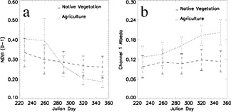
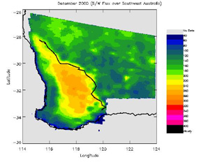
The Southwestern Australian region has a Mediterranean type of climate, and in the winter rainy season wheat and barley crops are grown in the agricultural areas. During the drier summer season, the agricultural areas become bare after harvest. This leads to differences in land surface characteristics that exhibit considerable seasonal variation. Seasonal variation of Normalized Difference Vegetation Index (NDVI) show that the amount of surface vegetation in the agricultural area varies significantly through the year, while the changes are much smaller in the native vegetation areas (Figure 2a). Winter crops are responsible for larger values of NDVI over agricultural areas during winter and early spring. However later in the spring and during summer months, a sharp decrease in values of NDVI accompanies the harvesting of these crops. Differences in land use also result in the albedo being different (Figure 2b) over agricultural and native vegetation areas (Lyons et al., Ray et al., 2003). In general, albedo is higher over agricultural areas throughout the year. However, the differences in albedo between these regions are highest during the summer months (Figure 2b) when harvesting of crops result in exposure of bare ground over agricultural areas. The albedo difference lead to the solar energy flux being drastically different between agriculture and native vegetation areas (Figure 3). During the summer months, our analysis of CERES data shows that the clear sky top-of-the-atmosphere solar flux is on average 65Wm-2 higher over the croplands.
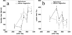
Seasonal variations of contrasting land surface characteristics cause the surface energy and moisture fluxes to be different over agricultural and native vegetation areas, especially during summer. Average values of satellite derived surface energy fluxes (Ray et al., 2003) for these areas during late spring and early summer are shown in Figure 4.
Earlier in the day, sensible heat fluxes are higher over agricultural areas, while latent heat fluxes are higher over native vegetation areas. Over native vegetation areas during early morning hours, enhanced evapotranspiration due to the presence of vegetation causes the sensible heat fluxes to be lower compared to agricultural areas. However, later during the day, as surface temperature increases and native vegetation starts to transpire less, sensible heat fluxes over these regions become larger compared to agricultural areas (Lyons et al., 1996; Ray et al., 2003).
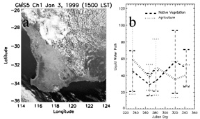
The difference in surface energy and moisture fluxes leads to variations in boundary layer evolution over these areas (Lyons et al., 2002). This could be responsible for observed differences in cloud formation and cloud characteristics between these areas (Lyons et al., 2002, Ray et al., 2003). Our analysis of GMS5 satellite data shows that during summer months convective clouds tend to form more frequently over native vegetation areas compared to agricultural areas. An extreme case of this behavior is shown in Figure 5a. On this day clouds form exclusively over the native vegetation area and the eastern boundary of the cloud field coincides almost exactly with the boundary between native vegetation and agricultural area. The mean cumulus cloud liquid water path is higher over agricultural areas during late winter and early spring (Figure 5b). However the pattern reverses during late spring and early summer (Figure 5b). This could be partly a consequence of differences in surface energy budget between these areas (Ray et al., 2003). During the growing season, latent heat fluxes are higher over agricultural areas, while after harvest they are higher over native vegetation areas. Thus during the growing season boundary layer air would be moister over agricultural areas in comparison to native vegetation, and vice-versa after harvest. These observations are consistent with results from our prior numerical modeling simulations that show increased cumulus cloud liquid water path in response to enhanced latent heat flux (Nair et al., 2003).
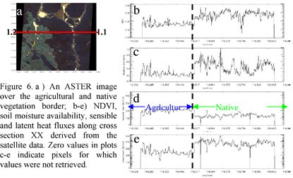
There is a natural thermal gradient going east from the Southwest coast of Australia towards the continental interior. Results from our satellite data analysis (Ray et al, 2003) and prior modeling and observational studies indicate that the nature of land use modulate the strength of this temperature gradient (Lyons et al., 1997; Lyons 2001; Nair et al.; 2003). Figure 6 shows summer month variation of NDVI, soil moisture availability, sensible and latent heat fluxes along a west to east cross section straddling both agriculture areas and native vegetation. Sharp differences in spatial distribution of surface energy budget variables and land surface variables are obvious from these plots. Note that the retrieved surface energy flux variables are valid for 1030 LST and will vary through the day. During the later hours of the day, sensible heat fluxes are expected to be higher over native vegetation. However, observations from prior studies (Ray et al., 2003) show that these sharp differences in spatial distribution of surface energy fluxes persists throughout the day. The implication is that the removal of native vegetation for agricultural purposes increases the magnitude of the temperature gradient in the west-to -east direction. The three possible responses to changes in horizontal temperature gradients are: 1) changes to sea breeze circulations along the coastal regions, 2) generation of circulations similar to sea breeze between agricultural and native vegetation areas in the continental interior and 3) changes to nocturnal low level jets that form in a direction perpendicular to the thermal gradient. Our studies show that land use definitely influences the regional climate of Southwestern Australia in multiple ways. In these studies, we address some of the mechanisms through which land use interacts with regional climate. However, the role of land surface heterogeneity needs to be further explored. In addition to identifying mechanistic interaction processes between land use and regional climate, a quantitative estimate of its impact, especially on local hydrology, is needed. Such an estimate is crucial for understanding the implications of land use change to agricultural productivity and ecosystem stability. |