Volume 3, Number 6, March 2013
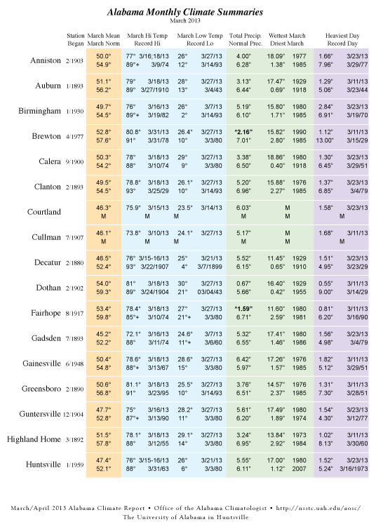
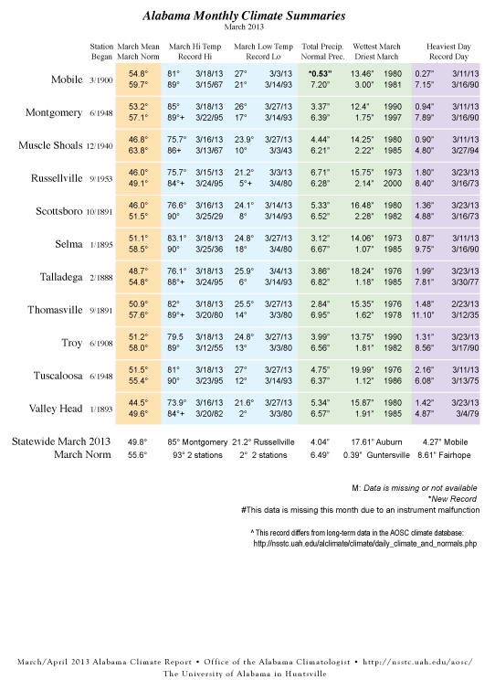
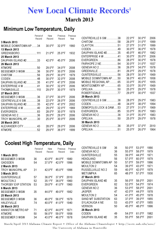
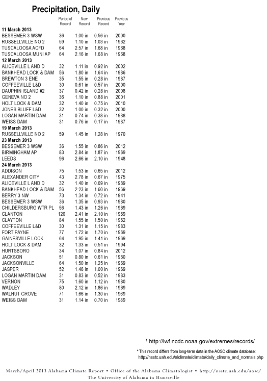
Forecasts of snow flurries in late March had us digging through historic weather records to answer some questions: Was this normal and, if not, how out of normal was it? During that search we uncovered some data that reminded me of my family's introduction to Alabama.
It was the first weekend of April 1987 when I brought my family to Huntsville for a first visit. We were here to look around because I was likely to accept an offer from UAH to join the research staff to work on global climate after finishing grad school in May. We had lived in South Dakota and Illinois during the previous nine years and after some brutal winters I was determined to move my residence further south.
It was a different time. New graduates would have several job offers. Climate was a relatively obscure science. Ronald Reagan was president. And it snowed in Alabama in April.
What I remember about that weekend was how cold it was, even though it was April and I was just below the 35th parallel. The newspaper reported that snow had fallen on Sand Mountain and points south. My main thought at the time was that if it was that cold here, think of what it was further north. But was snow in April normal?
It turns out that the weather of that weekend was well out of the ordinary. In 2013, we've just finished a very cold March in which flurries were reported even in the last week, and in some places March was colder than January. But on April 3, 1987, a wedge of cold air plowed into moist air across the south.
The Birmingham area got five to seven inches of snow (six at the airport). Fort Payne got nine inches of snow, Oneonta eight and Pinson seven. Anniston got almost three, Talladega four, Cullman and Haleyville two. Valley Head got ten inches of snow. In April. Mobile reported its first April snowfall on record.
One of the things some people remember from that event was snow sitting on the azalea and dogwood blossoms. Snow and ice collected on the leaves and flowers of tree limbs, breaking limbs and felling trees in many areas.
So, a chance of flurries in late March isn't unprecedented ... although it is unusual. Valley Head has seen snow as late as April 7, 1971, when it got almost two inches of snow. Several stations around the northern half of Alabama have seen three to five snow events in the last week or ten days of March during the past century.
Of course, snow isn't the only late winterish weather we need watch. The last frost and the last freeze of spring are also major concerns.
Though we didn't have snow, the Easter weekend of 2007 (April 6-8) was bitterly cold in Alabama, as many people will remember. After a pleasant March which spurred the growth of crops and trees, the Easter freeze essentially killed the emerging vegetation in the northern half of the state. The results were devastating, killing or weakening many plants and trees which — when combined with the terrible drought that summer — set many trees on a course for a slow death. The agricultural industry suffered terribly.
Freezing temperatures in April are not, however, that unusual in Alabama. There are several places where the AVERAGE last frost or freeze date is in late March or early April. The average last frost in Decatur is April 1, while the average last frost in Centreville is April 4. The AVERAGE last freeze in Moulton is April 5, in Russellville is April 7, in Cullman is April 10 and in Valley Head is April 15. But average last frost or freeze only means that the last frost is as likely to be after that date as before.
Spring has many ups and downs from year to year and, for 2013 so far, it's been mostly down.
- John Christy


